
The Region of Tuscany’s new network of St Francis trails.
Back in 2014 when I was researching the first edition of The Way of St Francis guidebook I was faced with a challenge. Since the Tuscan portion of the walk was not yet officially recognized by the Regione Toscana I would have to rely on other guidebook writers for the route. That worked for all the stages to Santuario della Verna, where the official Umbrian route begins, but there was a problem with the other guidebooks: they didn’t have a way to walk out of Florence. The most popular guidebook recommended taking a train to nearby Sant’Ellero, a 20km ride from central Florence, and beginning the walk there.
To me it doesn’t seem right to start a walking pilgrimage with a train ride, and that’s what my friend, Jacqueline Ziendlinger felt, too. She had already translated one of the German guidebooks for me and was determined to find a good way out of Florence, so the two of us walked various trails around the Renaissance capital looking for a good route. Finally, I shared the problem with Salvatore Accardi, pilgrim travel expert in Rieti, and he passed on his own solution. I included that in the book as Stage 1 — Florence to Pontassieve — and was proud (thanks to Salvatore) to write the first guidebook that led pilgrims on foot all the way from Florence to Assisi and Rome.
Five years later the Regione Toscana has finally adopted the Way of St Francis as an official, Tuscan pilgrim route. They now actually have FIVE routes to La Verna, including two from Florence. Best of all, they’ve approved a brand new walk from Florence to Pontassieve as the first stage of one of their routes, a stage that lines up exactly with the itinerary of my book and the Dutch and German books. Last month I had the opportunity to walk the path and it’s an improvement, saving a total of 4 kilometers and avoiding a few of the annoying hills of the original route. The walk was pioneered by Leonardo Cortese of Pontassieve, who should get credit for creating a great new route for pilgrims. I had the pleasure of staying overnight at his place in Pontassieve, Leonardo’s Rooms, which I highly recommend for pilgrims. I’ve included a slight variation of it as my new Stage 1 route for my book’s 2019 reprinting.
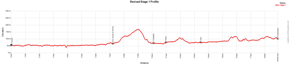
Profile of the new Stage 1 route. Now only one hill of 100m height.
The new stage begins at Basilica Santa Croce as did the old, but turns south immediately and for the next 7km follows the Lungarno — the riverside bicycle and pedestrian track that now will carry pilgrims all the way to San Jacopo al Girone.

The now-official Stage 1 route follows the north bank of the Arno River to San Jacopo al Girone.
From there it heads up the hill and momentarily touches the old route, comes back to Compiobbi where it rejoins the river, heads to Sieci as before, then follows a gravel road and path alongside the railroad tracks right into central Pontassieve. Total distance is only 18.9km and, for all but 150m, the track is free from highway shoulder-walking.

After Sieci the new route follows the railroad tracks instead of heading up toward San Martino.
There is one drawback. The old route has some amazing views back to Florence, which now are replaced with constant views of the Arno, which is not a terrible tradeoff. The primary advantages other than distance are that there is less walking on pavement and far fewer hills.
If all goes as planned, next spring the Regione Toscana will way mark the route for walkers. Over the next few days I’ll update the full set of 2019 GPX tracks so all of this year’s pilgrims can enjoy this new and improved exit from Florence. Meantime, tracks for the new stage can be found on Wikiloc here.
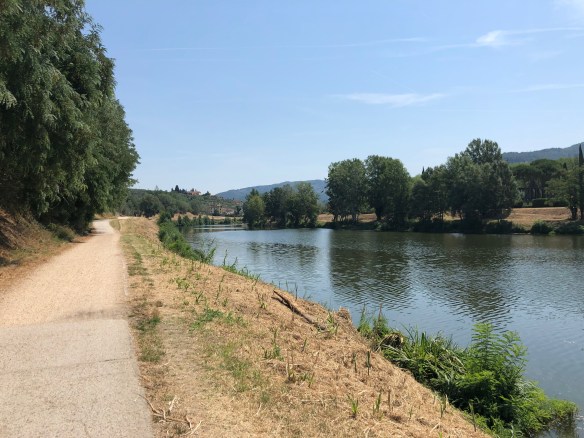
Walking along the Arno River on the new Stage 1 of the Via di Francesco outside Florence.